Saturday, 19 March 2016

Kawangware


Kawangware is one of Nairobi's lower-end residential areas. Kawangware covers about 10 square kilometres, and is rather densely populated. The region has also developed into a thriving commercial area.

In terms of location, Kawangware is roughly bordered to the north by Kangemi, to the east by Lavington, to the south by Riruta-Satellite, and to the west by Kabete and Dagoretti.

Kawangware, which is informally referred to as 'ungwaro', in sheng (slang), is broadly divided into two main sections - Kawangware 46 and Kawangware 56. Kawangware 46 is so-named after the public transport route that traverses the area. This is the general area that begins at 'Congo' (the junction of Gitanga Road and Macharia Road) and runs all the way to 'BP' area (the junction of Gitanga Road and Naivasha Road, near Precious Blood School, Riruta).


The junction of Naivasha Road and Gitanga Road, found at the 'BP' area, located at the border of Kawangware and Riruta

Some of the villages that make up Kawangware '46' include 'Coast' (so-named after a butchery there that was known as Coast Butchery), and Msalaba. Kawangware Primary School, that was renowned for its prowess in drama, and the Kawangware market are also located in the '46' vicinity. The Kenya Bus Service Management has got a garage and overnight terminus at the end of '46', near Precious Blood School.


 The gate of Kawangware Primary School

Kawangware '56', on its part, is named after the public service route serving the area. '56' is the general area that starts at 'Congo' and goes all the way to Kanungaga, not far from the valley that forms the border with Kangemi. Kanungaga is the terminus of bus route 56.

'Congo', which is at the border between Kawangware and Lavington, has for many years been known for its numerous Busaa drinking dens complete with traditional isukuti music players. Many years ago, I used to see the ingredients of the Luhya traditional beer being roasted on large metallic trays over wood fires. One could also see groups of men seated in and around the dens, enjoying the porridge-like brew. Some of the revelers who were overcome by the intoxicating effects of the beer could be seen dancing merrily by the roadside.


 A section of Kawangware '56' near 'Congo'

Some of the 'villages' forming Kawangware '56' include Kabiro, Stage 2, and Kanungaga. Kanungaga area was made famous by prophetess Mary Akatsa who has her church there. If I remember well, the church was known as New Jerusalem. In 1988, at the height of her ministry, she claimed that Jesus Christ had visited one of her church services. I remember seeing a picture of the so-called Jesus and thinking to myself that he looked more Indian than Jewish. But, at the time, 'Dada Mary' (as Akatsa was popularly known) was a huge sensation, and not many in the area dared question the authenticity of this Jesus. Pictures of the man were printed and sold to church members as well as interested area residents.

Other outlying areas that are part of Kawangware '56' include Kamitha and Gatina which border Lavington, as well as Muslim, which stretches all the way to the route 46 bus terminus.


 A section of Muslim area in Kawangware


 A stretch of Gitanga Road, at the terminus of bus route 46

Besides Kawangware '46' and Kawangware '56', the areas on both sides of Naivasha Road, beginning at Deliverance Church, Riruta, all the way to the Precious Blood School area, are also considered as part of Kawangware. Included in this stretch are areas such as 'Ciugu-ini', Kawangware market, and 'BP'. 'BP' was so named after the Shell petrol station there, which was formerly a BP franchise service station.
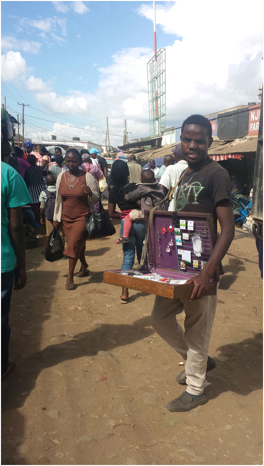

 Activity at the Kawangware Market

The land in Kawangware is mostly owned by members of the Kikuyu ethnic community, who are indigenous to the area. Most residents of Kawangware '56' are members of the Luhya community, who hail from Western Kenya. They reside here as tenants in the many housing estates owned by Kikuyu landlords. The Luhya population in '56' is significant, such that bus companies serving western Kenya have opened booking offices here.
Kawangware '46', on its part, is a little more cosmopolitan. Many of the Kikuyu landlords have also remained on their land in the '46' area, living next to the rental flats they build.

Public transport is somewhat equally owned between members of the Kikuyu and the Kisii ethnic communities. Kisii matatu owners have largely concentrated on the '56' route while majority of the Kikuyu ply '46'.

Kawangware is an intensely religious area, and is dotted with numerous churches. Among the leading denominations here are the Anglican Church, Redeemed Gospel Church, Full Gospel Church, and Deliverance Church. Others include the Free Pentecostal Church and the Orthodox Church. Of note is the fact that Kawangware is replete with indigenous African churches. The most common of these is the African Divine Church (ADC) whose members hold large processions along the road on Sundays. They will be seen in their white robes, prayer caps, and headscarves, singing and dancing to the music of drums and triangles. At the head of the procession is always the person bearing the denomination's flag.

Interestingly, Kawangware, though in Nairobi County, is part of the Dagoretti North electoral constituency.

-The End-

Saturday, 23 January 2016

Drive to Kitui Again

Apart from the Machakos route, there is another way of accessing Kitui from Nairobi. This route goes via Thika Town, and is 187 kilometres long. From Thika, one travels along the Thika-Mwingi highway (Garissa Road).

The first significant point along this route is the Donyo Sabuk/Kilimambogo junction that leads to the twin towns of Kangundo and Tala. The junction, which branches off to the right, also leads to the 14 falls on the Athi River, and is located about 30 kilometres from Thika.

The area to the left of Garissa Road, at this point, is dominated by pineapple plantations. The next major point that one comes to is Ngoliba Market, found 13 kilometres from Donyo Sabuk. The little Centre is surrounded by vast plantations of pineapples and coffee.

5 kilometers from Ngoliba, one comes to the National Youth Service (NYS) Yatta Field Station. The institution's buildings are situated on both sides of the road.

11 kilometers from the NYS establishment, you come to the Kithimani Town junction. This is the junction to the road that leads to Makutano Market on the Machakos-Kitui highway. The road became famous when, in 2013, the Machakos County Government tarmacked the entire 33 kilometers in 3 months and at half the conventional cost.

Kithimani is an important government administrative centre. There is a police station and law courts, among other government offices. At the Kithimani junction you will be greeted by scores of eager hawkers selling fruits and vegetables. When driving, one has to be careful not to knock any of them down.

9 kilometers from Kithimani is a small town called Sofia. 7 kilometers from Sofia, and 66 kilometers from Kitui, is Matuu Town. The town has grown to be very big and busy in recent times. It is complete with schools, hotels, churches, service stations, retail shops, and government offices. It is difficult to imagine that at Kenya's independence, in 1963, there was only one shop here. Of note is the fact that the late former Commissioner of the Kenya Police, Philip Kilonzo, hailed from the Matuu area.

14 kilometers from Matuu is Kanyoonyoo Market. At this shopping centre is found the junction of the road to Masinga and Embu, which branches off to the left. There is not much in the surrounding area except vast acres of uninhabited land used for ranching.

4 kilometers from Kanyoonyoo, one comes to the junction with the road leading to Kitui and Kibwezi. The road branches off to the right, towards Kitui which is 48 kilometres away. This junction, although in the general area of Kanyoonyoo, is known as Kalandini. Kalandini is an old name for the place, which many of the younger people may not be familiar with. In the '70s and '80s, before the road to Kitui was tarmacked, there was a police barrier near this junction. This barrier is probably what was changed to be the road block we have there today.

There is no human settlement and commercial activity at all at this junction. The scenic view of the countryside, however, makes the drive worthwhile. From Kalandini one goes past the two market centres of Kathiani and Katutu before coming to Kabati, a rapidly growing town located 19 kilometers north of Kitui. Kabati is a government administrative centre that has a market. From Kabati there is an untarmacked road that branches off to Migwani Town, eventually reaching Mwingi Town.

From Kabati, the next milestone is the Syongila junction, found 3 kilometers from Kitui Town. The Syongila junction is the point at which the Kitui-Kibwezi Road meets the Machakos-Kitui Road. Not far from Syongila, to the left of the Kitui-Kibwezi Road, is the Matinyani shopping centre.

From the Syongila junction you then drive into Kitui Town.


-The End-

Wednesday, 31 December 2014

Lavington

Lavington is one of Nairobi’s upper-class neighbourhoods, and one of the oldest, having been established in the pre-independence days. It has its roots tied to the St. Austin Mission which was established in the area by the French Holy Ghost Fathers. The estate is named after Ralph Payne, a British political leader who hailed from Lavington in Wiltshire, England. Baron Lavington, as he was referred to, was governor of Leeward Islands in the Caribbean.

Lavington is a vast residential area that is bordered by Waiyaki Way to the north and Ngong Road to the south. To the east it borders Kileleshwa and Kilimani, while its western extents border Kawangware and parts of Kangemi.

James Gichuru Road (formerly known as St. Austin’s Road) traverses most of Lavington. It runs from its junction with Gitanga Road, popularly known as Stage 11, past Lavington shopping centre, all the way to its junction with Waiyaki Way, next to the ABC Place shopping centre. A drive along James Gichuru Road is an easy way of seeing Lavington at a glance.

At the heart of Lavington remains Lavington Green shopping centre. The shopping centre has been there for as long as I can remember, and, for a long time, consisted of less than ten shops and service establishments. There was the Post Office, a dry cleaning shop, and a well-stocked toy and gift shop that was run by an Indian man. There was also a snack shop run by an Indian that served the best meat pies and samosas that I have ever eaten anywhere. We used to buy a 300 ml Fanta soda there at 1 shilling and 80 cents in the early ‘80s. At the shopping centre there was also a Salisbury’s supermarket that sold expensive-looking chocolates and wines, among other things, an ice-cream shop that made me love the Lyons Maid brand, and a brightly-lit branch of Gilani’s butchery. Above the shops, at the shopping centre, was one floor of residential apartments. As a kid I always wondered what kind of people lived there.

The shopping centre had beautiful, grassy lawns that we played on as kids on our way from school. Adjacent to these grounds was the public bus stage which served as the terminus for the following Kenya Bus Service (KBS) routes:

• 47 to city centre via Gitanga Road, Argwings Kodhek Road, and Valley Road

• 47A to city centre via Gitanga Road, Chaka Road, and State House Road

• 48 to Huruma Estate via Gitanga Road, Othaya Road, Kileleshwa, Westlands shopping centre, and city centre

• 49 to city centre via James Gichuru Road, Waiyaki Way, Rhapta Road, and Westlands shopping centre

• 50 (the reverse of route 49)

Over the years, Lavington shopping centre has totally transformed in appearance, to become what is today known as the Lavington Curve. More commercial establishments have been added, such as the Kengele’s Pub and Barclays Bank. A six-floor office and commercial block known as the Lavington Mall has also been set up, completely altering the landscape of the area.

Within the vicinity of Lavington shopping centre is the Lavington United Church which has been a permanent feature of Lavington. The community church is run jointly by three denominations – Methodist, Presbyterian, and Anglican. Pastors from the church would come to us at Lavington Primary School to offer pastoral lessons on Wednesday mornings. The church also runs a nice little kindergarten.

Apart from Lavington shopping centre, Lavington also has another shopping centre known as Valley Arcade, which is located along Gitanga Road. The shopping centre has given the area the name Valley Arcade. Some people, particularly those who live in the neighbouring Kawangware Estate, call the area Bernard. The Methodist Guest House and Conference Centre is located in the Valley Arcade area of Lavington. The Valley Arcade shopping centre, which was actually bigger than Lavington shopping centre, has itself changed over the years. Though not as big as Lavington now, it has substantially grown with additions and extensions to the existing buildings.

Residential development in Lavington is mainly made up of single bungalow compounds. This is what you will find along roads like Convent Drive and O’Washika Road. In some parts of the posh estate, such as Amboseli Road and Gitanga Road, maisonettes and apartment blocks are rapidly coming up.

A number of foreign missions have their residences in Lavington, among them the Uganda High Commission, the Egyptian Embassy, and the Chilean Embassy.

Lavington is well-endowed with educational facilities. It has a myriad of both public and private schools. The two public schools in the area are Lavington Primary and Muthangari Primary (formerly known as Bernard Estate Primary School). The rest are private schools which include prestigious institutions like the Strathmore School, the Saint Mary’s School, Nairobi, the Loreto Convent School, Msongari, Saint Austin’s Academy, the Nairobi Jaffery Academy, the Rusinga School, the Braeburn School, and the Braeside School.

Lavington is served by Muthangari police station which is found along James Gichuru road, not far from the Saint Mary’s School. One of the tributaries of the Nairobi River runs past the area.

There are virtually no empty, undeveloped spaces in Lavington. Even with land prices in the region of 250 million Kenya shillings per acre, all of the prime land has been taken up, 95% of it to put up residential property. The little area left for expansion seems to be on the western side that borders Kawangware.

There is a variety of eating places in Lavington, both for fast food and for fine dining. These include Big Square, Adega Restaurant, Innscor Kenya, Pampa Grill, Peri Peri Grills, Monikos Kitchen, Subzone Restaurant, and Le Palanka, among others.

Lavington is one of the most beautiful neighbourhoods in Nairobi, if not the most beautiful. But why take my word for it? Take time to drive through and see this for yourself.


The junction of James Gichuru Road and Gitanga Road, popularly known as 'Stage 11'


The new shopping mall at Lavington shopping centre.


The Lavington United Church.


A new commercial block along James Gichuru Road.


A section of the old Lavington Green shopping centre showing some construction extension.


Residential houses in Lavington.

Wednesday, 3 December 2014

Athi River


ATHI RIVER
It will be helpful to state, from the outset, that there are three Athi Rivers:

1.      The River Athi
2.      Athi River town
3.      Athi River district

River Athi is Kenya’s second-longest river and has its origins around the Ngong Hills area. From there it traverses the Athi-Kapiti plains on its way to the Indian Ocean which it pours into at Malindi on the Kenyan coast. At its lower stages the river is also known as the Sabaki or Galana. Not too far from the main Athi river is a smaller, seasonal river known as the Stony Athi.

Athi River town is located off Mombasa Road, about 30 kilometres south of Nairobi. The old, dusty town is predominantly an industrial centre. One of the oldest industries here is the Kenya Meat Commission (KMC) slaughterhouse. The government-run abattoir processes meat products for export. While its products are delicious, the facility is notorious for the unpleasant stench it emits frequently as a result of the waste matter from animalslaughter processes.

In addition to being an industrial centre, Athi River town is also a government administrative centre. The sub-county (constituency) here is known as Mavoko and is part of Machakos County.Previously, Mavoko was part of the larger Kathiiani constituency in Machakos district.
Other facilities to be found in Athi River town include a municipal market, Athi River District Hospital, the Kenya Meat Institute, banks, and Law Courts.

Athi River district is the vast area after Mlolongo Township all the way to the Lukenya Hill. Limestone is abundant in the area and there are a number of cement factories to be found here. Some of these include Mombasa Cement, Bamburi Cement, East Africa Portland Cement, Savannah Cement, and National Cement.

One of the significant industries located in this area is the Athi River Export Processing Zone which covers the area between East Africa Portland Cement staff quarters and Kitengela.
Athi River district is one of the few areas around Nairobi that still has open space for human settlement. The area is now a major residential area serving those who work anywhere between Nairobi city and Machakos town.

Athi River town hosts old estates such as Makadara, Embakasi, and ‘Site’. There are, however, many newer estates that have sprung up in the wider district, particularly on your left as you drive from Nairobi towards Machakos. One of the first ones to have come up is Valley View Estate just after Mlolongo.Next is Sheshe Gardens,and not far from there is Delta Plains, in the area locally known as Sabaki. Further down the highway one encounters Everest Park and Blue Hills View estates. Further off the highway are beautiful developments such as Lapfund Gardens, Sunset Boulevard, Pine City, and Graceland. Much further down Mombasa Road, past KMC, is Sidai Village.The last major estate isthe beautiful Green Park development, which is next to the Stony Athi. Interspersed with these major estates are individual bungalows and maisonettes.

Athi River district is well served with schools. The most notable ones are Lukenya Academy, Anthena School, Kiuini Preparatory, Star Sheikh Academy, and a couple of public schools. We must also remember that Daystar University’s main campus is to be found in Athi River, at the foot of the Lukenya Hill.

Athi River has been predominantly inhabited by the Kamba ethnic group, but the area is fast becoming cosmopolitan. As Nairobians settle in areas such as Ongata Rongai, Ngong, Ruai, and Kitengela, they are also moving to Athi River.


The River Athi


Lukenya Hill as seen from Athi River


A new cement factory in Athi River


A train going past the KMC slaughterhouse at Athi River


A residential development in Athi River

 
-End-

Thursday, 6 November 2014

Kitengela


Kitengela
Kitengela is a little but thriving town situated about 30 kilometres south and west of Nairobi, on the highway to Kajiado and Namanga. Located in the Kapiti plains, the dusty town is part of the Kajiado East constituency in Kajiado county.
For a long time Kitengela was just a weekend getaway spot for Nairobi city residents. The numerous hotels and restaurants here made it the ideal destination for those wanting to indulge in nyama choma. In the last ten years, though, the town has rapidly transformed into a robust urban centre.
The central business district of Kitengela has become very congested. Every morning and evening, quite surprisingly, there is a traffic jam. The older residential estates of New Valley, Milimani, Upper Hill, and Noonkopir have continued growing rapidly. In addition, there are a number of newer residential areas coming up, particularly around the Yukos Service Station area. Beautifully planned residential developments such as the New World Gardens are also coming up.
The number of hotels and restaurants in Kitengela has increased. Nomad Hotel, which has been in existence for a while, is still thriving at the heart of the town. Other hotels that have come up lately include Esidai County Hotel, Grey's Oak Hotel, Kaputiei Safariland Hotel, and the Yukos Service Station Restaurant. Two notable clubs in the area are Club 360 and Club 411.
The educational sector is well represented by schools such as the Kitengela International Schools, Acacia School, and the Ideal School. A number of colleges are to be found here such as the Kenya College of Accountancy (KCA), Riccati Business School, and the East African University.
Kitengela hosts more than ten financial institutions. Among them are the Kenya Commercial Bank (KCB), Co-Operative Bank, Equity Bank, Consolidated Bank, National Bank, Post Bank, Faulu Microfinance, Musoni Microfinance, and Kenya Women Finance Trust (KWFT), among others. The financial space in the town, quite clearly, is heavily contested.
Kitengela is quite cosmopolitan. The dominant ethnic groups here are the Kamba and the Kikuyu, but the Kisii and Luhya are also to be found in fair numbers. The Maasai, who are indigenous to the area, are to be found more in the manyattas in the outlying areas of the town. They will only come to the town to deliver milk supplies to hotels, and animals to the slaughter house. They will also be seen selling beaded jewellery and traditional artifacts.
Due to its rapid growth, Kitengela is expanding along Namanga Road, in the direction of Isinya. Land prices are escalating with this growth of the urban centre. A quarter of an acre is going for more than Kshs. 4 million in the town. In spite of this, the construction industry is booming here. After Syokimau and Ongata Rongai, interested home buyers and builders are now turning to Kitengela for settlement.
We will keep an eye on the place and inform of any new developments.


The Mombasa Road-Namanga Road interchange leading to Kitengela


Busy traffic on Namanga Road at Kitengela


A modern commercial block in Kitengela


A modern fast food outlet in Kitengela


A new hotel in Kitengela


Residential development around the Yukos area